
Torres Del Paine National Park
- willowrolfe
- Nov 10, 2025
- 9 min read
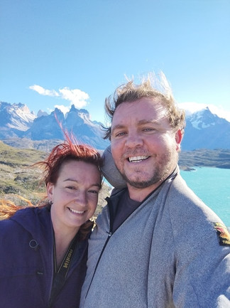
After leaving Puerto Natales that morning, we headed north. Soon the boring grasslands gave way to something infinitely more interesting. The Torres peaks were now our backdrop and that could only mean one thing: our next destination was Torres del Paine National Park. Probably the most famous national park in Chile, and a bit of a logistical nightmare for us. That was tomorrow’s problem though. For today we turned off the road just before the gates and camped alongside the Río Serrano. Despite the cold, we sat outside to eat our dinner and appreciate the view as the dying light blushed the snow on the mountains in front of us a rosy pink.


Our plan was to enter the park the next day, before the staff arrived at the visitor centre. There were two reasons for this: one, it would be free (which really was more of a bonus because we would have paid anyway), and two, it was the only way we could go in with the cats. While we felt a little bad about skipping the entrance fee, stopping to pay would mean they would ask if we had pets and quite possibly check the van. Given the choice of missing the park entirely, or sneaking in, we chose the latter. As with all national parks, pets are not allowed. Unfortunately, having cats means that you can’t even really do something like “doggy day care”, as it doesn’t really exist for cats. So we improvised.
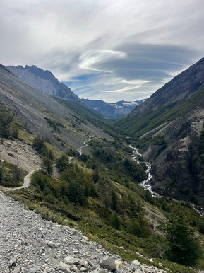
The next morning we were up at sunrise, passing through the barriers at 8am. Staff were already arriving, but we just drove on through and hoped for the best. Because our cats weren’t allowed, we had decided we would keep them contained inside the van at all times. Despite this, we’d get thrown out instantly if someone saw them. As they’re not fans of being contained, we planned to power through the park as quickly as possible. While we would have happily stayed and explored properly, this wasn’t fair on them, so we decided this was the compromise: 48 hours in the park. After crossing the entrance, we headed inside on rough corrugated roads, before taking a fork at the first junction and heading to Grey Lake.

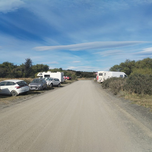
Here is one of the ranger stations and an enormous car park. It’s also one of the only places in the park that permits overnight camping which is not a campsite — those being rather expensive. We decided we wouldn’t stay there because of the proximity to the rangers, but we wanted to do some hiking. We parked Ruby as far away as possible and drew all the curtains. We hoped that soon the car park would fill up and obscure her completely, as our girls loved to open the curtains and sprawl on the work surface or dashboard in full view.
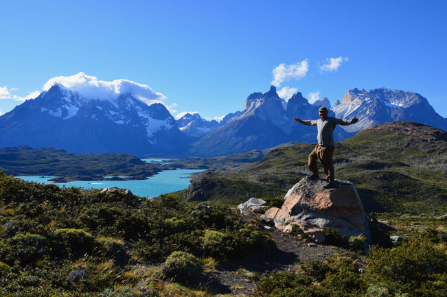
Our first hike was the Ferrier lookout: a short, sharp hike that leaves directly from the car park and ascends around 700m in about 3km. We’d done a little bit of hiking, but not a huge amount, so we slowly puffed our way up to the top, where we were rewarded with an outstanding view of the lakes and mountains of the park.


As gorgeous as it is, you wouldn’t want to stay long perched on this rocky outcrop, as the wind that blew up here was ferocious. Not only that, but we had more things to cram into our short stay.

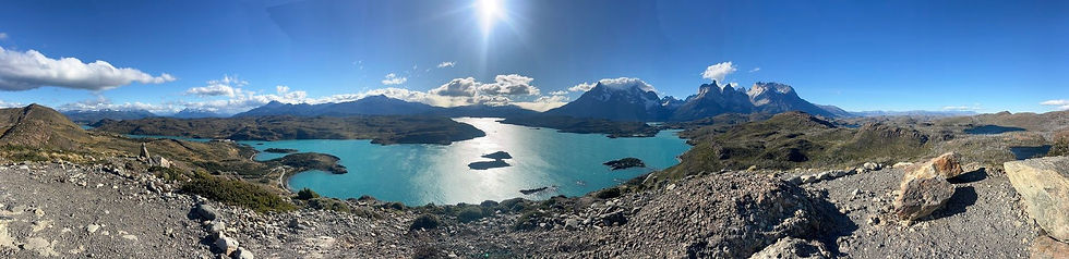
Back down at the car park, we checked up on the cats (currently sleeping — no dramas yet) before heading out towards Grey Lake. Our friends had done this recently, taking it one step further and getting the boat tour that runs from the small sandy bay all the way to the glacier at the end. Once there, you get served a nice dram of whisky with a chunk of glacier in it, apparently. As nice as that sounded, it wasn’t really an option for us with the pets, so we did the next best thing and settled for another small hike.
Leaving the car park, you cross a large bridge labelled with a wind warning system. According to that, we were at amber — winds of between 50–80 km/h. Once the winds get too high, access is closed for safety. We crossed over and dropped down a little to reach the beach. There’s no defined path here, just head across the sand to reach a separate little island. This was a popular hike, firstly with several tours heading to the island, and also with crowds of people heading over to the jetty to catch the boat tour.

We picked our way across the beach, leaning into the wind, before we reached some small stairs chipped into the rock face on the other side. From here you can do a little circuit of the island. At the end, you get views down the lake with a hint of glacier far away in the distance. In the foreground, you get a far closer look at the sizeable icebergs we had seen from our high lookout earlier.


The tours retraced their steps here, but we continued onwards on a lesser-used path, turning the walk into a loop before returning to the beach. Bracing ourselves against the wind once again, we zigzagged back towards Ruby.
In an ideal world, I would have crawled inside, rested my legs, and possibly had a nice hot chocolate. But that wasn’t on the menu for today. Instead, we retraced our route back out to the main road of the park and then turned left to continue heading further in. We decided we’d do one final look — a popular short hike to the Condor lookout. We had been blessed with the most fantastic weather and we intended to take full advantage.
This was a little more stressful, as instead of being able to tuck ourselves away at the back of a car park, we were parked just on the side of the road. The cats were getting fidgety, and as we were on the main road too, rangers were driving past. We hoped they’d behave themselves just a little while longer while we powered up this remaining hike. The problem is that because Ruby draws so much attention, people like to come up really close and look at all of the stickers and so on. When the cats hear voices outside, they tend to come to the windows or howl. Not ideal. Still, we were here now, so we went for it.
It’s only about a 45-minute hike to the top, but straight up a hill, and after already completing two other hikes that day we were getting a bit tired. Still, with the brilliant blue skies and crystal-clear views of the mountains, we pushed on to the top.
It was worth the effort.


A much easier descent later, we were back at the car. We quickly hopped in, restraining the screaming cats before we opened the curtains. As soon as we started driving they settled down again immediately. After 20 km of hiking that day, we savoured a slow drive through the rest of the insane views as we continued northwards.


We debated driving down to have a look at the Salto Grande waterfall, but decided against it. Not only is it more walking, but the car park here has a reputation for flipping over people’s cars in the wind. That was absolutely not something we needed to be doing, so we observed it from a distance across the lake and continued on. We reached the northern entrance, but we weren’t ready to leave yet. Turning left, we headed to our destination for the night.


They are strict about camping here, and we weren’t sure whether or not we would be allowed to stay where we wanted to. Our plan was to be up at dawn the next day and to hike the famous Base Torres trail. This takes you to a startlingly blue lake at the bottom of the most famous Torres mountains. We hoped to be able to stay in the car park, in order to have an easy and early start. As we arrived, we saw many other campers who looked like they’d been there at least a day or two, parked on the grass verges at the side of the road. After speaking to a couple of people, the consensus was that this wasn’t official but was tolerated if you were discreet. Considering we had the cats, we planned to stay inside with them anyway, and so we didn’t even get our camping chairs down as we set up for the night.


The next morning came too soon. But we had been lucky to have a nice still night and a good sleep at least. After our walks yesterday, my legs hurt before we even started. This was going to be a challenge. We packed water, food, layers, and cameras before setting off around 7am.
The first part of the hike is a straightforward long, straight path that runs parallel to the road, past the visitor centre and hotels where we could see would-be hikers at their morning breakfast buffets. After a couple of kilometres, you cross a small bridge and the path diverts up a hill, marking the start of the ascent.

We picked our way through the soft sandy track, worn down several feet into the ground by the frequent passage of hundreds and hundreds of feet. Around halfway up this first hill, we stopped for a breather and some breakfast.
After reaching the top of this first steady upward section, more people were beginning to appear. Several had already overtaken us. We were definitely a bit slower than normal, but at least we had the whole day ahead of us. From the top of this hill, you get a small respite from the climbing as the path heads down the other side into the valley.


We picked our way down, watching the horses crossing the river at the bottom as they brought supplies up to the hostel here.
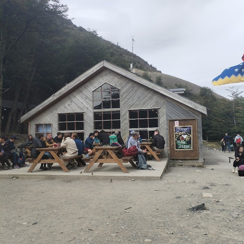
Before long, we reached the hostel itself. We refilled our water bottles, wondering what extortionate price they must charge to camp here. The side of the valley here is lined with rooftop tents mounted onto the hillside — these are commonly hired by people completing the very popular multi-day hikes of the O or W trek.
We continued on. The trail here climbs gradually, undulating up and down again as it follows the natural banks of the river. A little further up we crossed it again, the ascent steepening slightly as we hit the other side. On the whole, it wasn’t too bad yet.
It’s a 10 km hike out, of which the final kilometre alone is supposed to take an hour to complete. As we reached the edge of the forest section, the path opened into a rest area with large benches along one edge. Signs indicated that the Torres Base hike continued up the hill to our left, while the trail ahead continued on to complete the earlier mentioned longer hiking routes. From here we knew we had only one kilometre left to complete but still around 400 metres to ascend. Here you lose the trail — or rather, it’s hard to call what follows a trail at all. What comes next is a tough, and at some points near-vertical scramble up giant boulders and scree. It’s more climbing than hiking, and after already walking around 9 km that day and 20 km the day before, we were tired. Slowly, we hauled ourselves up huge rocks, around tree roots, and through loose shingle slopes. Parts of the lower section remain in scraggly trees, but as you climb higher you leave these behind and can see the tiny figures of other hikers above you, reminding you just how much further you’ve got to go.


After a fairly tough hour, we finally looked down at the line of people snaking up below us rather than above. The trail then levels for the last few metres as it skirts along the end of a rocky overhang before finally cresting the edge and rewarding you with impressive views down to the lake and the mountains dominating the backdrop.


We stopped for a very well-earned lunch, a drink, and a good rest before we thought about going back down. In some ways the descent is worse. It’s not a cardio challenge anymore, it’s all about the knees. And my knees hate it. Muscles shaking and with legs like jelly, we stumbled back out at the bottom with the knowledge that we still needed to walk 9 km back to Ruby.
We slowly plodded back to the hostel, mainly downhill. Once there, we made an exciting discovery: we found out that, contrary to what I thought, contactless payments on your phone work without internet. This glorious discovery meant that we could sit down at the benches and enjoy two very well-earned pints of Calafate beer before attempting the final part of the route.


By the time we got back to the camper, we were both very tired. The cats, of course, were full of energy! They’d been sleeping all day and wanted nothing more than to go outside. As much as we would have liked to just relax the rest of that day, we knew we had to move on.


Comments